|
|
|
Further informations
Click on the name of the island
for further information and virtual flight |
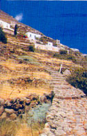 |
ALICUDI
is the westernmost island of the
archipelago. The ancient name Ericusa is due to the
rich vegetation of heather, of which the island is
covered. The heather is part of the history and life
of the islanders, who use it always to make roofs of
huts, and, with the root, stove pipe. Alicudi is a
cone round which culminates with the relief Wire
Harp and has an area of 5.2 sq. km. The inhabitants
called alicudari are about 140 and live in the only
town of Alicudi port, fishing and small agriculture.
Of volcanic origin, the island is made up largely
from the extinct volcano Montagnola, born about
150,000 years ago, after effusive and explosive
eruptions |
|
 |
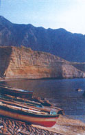
FILICUDI
Formerly
called Phoenicusa (rich in ferns), with Alicudi is
geologically the oldest of the islands. It has an
area of 9.5 square kilometers and its highest point,
the Pit of Ferns, is 773 meters. The inhabitants
called filicudari are about 250, scattered in the
three main towns: Filicudi port, Pecorino at sea and
Valle Chiesa (Valley Church). The island is slightly
oval in shape and extends to the southeast in the
promontory of Capo Graziano is a small peninsula
connected to the main part of Filicudi by a strip of
land. The island is composed of the products of six
volcanic centers. The oldest had to be located in
the sea near the coast of Fili di Sciacca (Sciacca
wires). |
|
 |
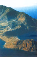
LIPARI
Is the largest island of the Aeolian archipelago. It
has an area of 37.6 square kilometers and is 24
nautical miles from the Sicilian coast. Its
inhabitants, called Liparoti or Liparesi, are
about 9000 and live in the villages of the island:
Canneto, Acquacalda, Quattropani and Pianoconte.
With the exception of Salina, all the administrative
responsibility of the other islands are depending
from Lipari. As the Aeolian archipelago, Lipari has
volcanic origins. The oldest part of the island is
the west, where, between 160.000 and 134.000 years
ago, we identified 12 volcanic layers, including the
Timponi. At this stage of intense eruptions followed
a long interval of volcanic activity. In the second
period, about 100.000 years ago, it created the
volcano of Mount St. Angel. The volcanoes of the
third period (40.000 to 8.000 years ago) erupted
pumice, forming a series of peaks, including Mount
Guardia and Monte Giardina. After a long pause,
eruptive activity resumed in the north east with the
launch of huge amounts of pumice which formed Monte
Peeled, and the issuance of the obsidian of Rocche
Rosse (VII) c. d. C. Even in historical times there
were eruptions of pumice that covered with a layer
of fine dust levels in the oldest archaeological
site of Diana and in the acropolis of the
Castle |
|
 |
PANAREA
Panarea Island, formerly known as Hycesia, is
the smallest island of the Aeolian archipelago. It
has an area of only 3.4 square kilometers and is
11.5 miles from Lipari. Its 280 inhabitants, called
panarioti, living in three districts: Ditella, St.
Peter and Drauto. Panarea is framed by the nearby
little islands of Basiluzzo, Dattilo, Bottaro,
Spinazzola and the rocks of Lisca Bianca, Lisca
Nera, the Panarelli and the Ants. Scientists believe
that Panarea and the islets and rocks that surround
it are the remains of an ancient underwater volcano
in part submerged by the waters in the interglacial
periods. In the present emerged is possible to
recognize a single volcano on whose flanks were
implanted several minor eruptive centers. |
|
|
 |
SALINA
After Lipari, is the second largest
island of the archipelago: about 27 square
kilometers of surface.
And 'the highest of the 7 islands with mountains
"Fossa delle Felci"
(Trench
Ferns) and
"Monte dei Porri"
(Mountain
of Leek) too long extinct volcanoes.
By the presence of these two peaks was its ancient
name Didyme, which means Gemini.
The present name derives from the presence of a
small lake from which salt is extracted, which was
then used for storage of capers and fish.
Is the second most populated island of the
archipelago with about 2,300 inhabitants. Is
divided into three autonomous municipalities:
S.Marina, Malfa and Leni. The fractions are called:
Lingua, Rinella, Valle Chiesa (Valley Church),
Pollara and Torricella.
In the area of Salina there are traces
of six volcanoes. |
|
|
 |
STROMBOLI
The most distant and most easterly of
the Aeolian Islands, Stromboli is about 22 miles
from Lipari.
The ancients called it Strongyle, the rotunda
(rounded).
It has an area of 12.6 sq. km
with about 420 inhabitants, called stromboliani.
Its active volcano is 920 meters above the sea and
the reefs are very deep (1200 m).
The island is a volcano that emerges from the sea.
The emerged part in activities lasting at least 2000
years, was mainly formed during two cycles of
activity.
An ancient cycle, consisting of solid
material by eruptions and lava flows, which formed
the entire eastern part of the island and the most
recent cycle, replaced mostly by lava flows, which
formed the western half of the island. |
|
|
 |
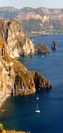
VULCANO
The ancient Hiera (sacred), the
second home of the Greek god of fire Hephaestus, is
the southern most island of the Aeolian archipelago
and is the closest to Sicily.
Is separate from the nearby Lipari by a channel
width of about 1.6 km.
Its area is 21 sq. km.
From the geological point of view, the island is
formed by volcanoes 4: Lentia, Vulcano Piano, Fossa
of Vulcano and Vulcanello.
The only considered still active volcano is the
Fossa of Vulcano (Pit).
The volcanic activity of this island
was known to ancient Greeks and Romans, who were
greatly impressed. |
|
|
|
|